In this work we developed a new method for evaluating geostationary wildfire algorithms with respect to timelines and reliability of initial wildfire alerts. The method combines geospatial fire records from operational agencies and multitemporal Landsat image analysis to identify new burn scars.
A single wildfire incident can span multiple pixels in the image. Because alerts are based on wildfire incidents (not pixels!) we developed an automatic algorithm that analyzes detected fire pixels and groups them into “events”, so that a new “event” in the imagery would suggest a potential new ignition.
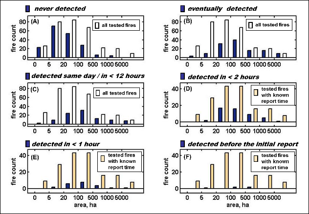
We then used these methods to systematically evaluate of the Wildfire Automated Biomass Burning Algorithm (WF-ABBA) over a 300+ wildfire incidents in California. We asked a question: How timely and reliably did WF-ABBA perform during the fire season of 2006?
We found that WF-ABBA performed best at what it was designed for: consistently re-detecting and monitoring large active fires; however, it was not optimal for detecting ignitions as early as possible. In sum, the potential of GOES satellites to shorten wildfire discovery times is currently underutilized. Our work also emphasized the potential of geostationary imagery for reducing wildfires latency in the Western U.S. and the importance of timely delivery of the images to the processing facilities.